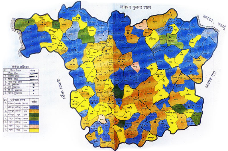

District Profile
The district Aligarh belongs to the administrative division Agra, U.P. and lies between 27'-29'11" north' latitude and 77'29'-78'26 east longitude. The district Aligarh is bounded by major rivers Ganga and Yamuna, from north east and north west sides, respectively. This district is surrounded by Palwal district of Haryana from north west, Badaun from north east, Bulandshahr in north, Mathura in west to south-east, Hathars in south and Etah in east and south-east. The total geographical area of the district Aligarh is 3691.50 sq.km.
Administrative Division :
District Aligarh is administratively divided into 12 blocks namely (i) Tappal (ii) Chandaus (iii) Jawan (iv) Khair (v) Lodha (vi) Dhanipur (vii) Akrabad (viii) Iglas (ix) Gonda (x) Atrauli (xi) Bijouli and (xii) Gangeri. Sub division wise blocks of the district Aligarh are given in Table 1.
Geomorphology :
In general the entire area is an alluvial plain, with a gentle slope from north-west to south-east. There are several natural depressions apart from those formed by the river valleys and drainage lines. Elevated sand ridges are also found especially in the west of the district Aligarh mostly in Khair and Iglas Tehsils.
District Aligarh is narrower in the north but gets wider in south and eventually passes into the adjoining district of Etah. This tract is characterized by the soil, which apparently looks clayey with imperfect natural drainage and in consequence the landscape is dotted with lakes and is disfigured by salt affected soil patches.
Served by numerous rivers and revulets, the more important being Ganga and Yamuna, few rivers like Karban, Rutba and Kali which pass through the district and remain almost dry except in the rainy season.
Climate and Rainfall :
In general the blocks in the west are drier as compared to those in the east. The temperature rises as high as 45 °C during summer and drops down to as low as 2.0 °C during winter. The mean maximum and minimum temperature of district Aligarh is 26.7 °C and 15.50 °C respectively. Monsoon starts in July and runs to September. The mean annual rainfall of the district is 800 mm, relative humidity 65%, Lang's factor 25.6 mm per °C and Mayer's (NS) quotient 76. Thus, the climate of the district Aligarh is semi arid.
Block wise analysis of district Aligarh.
| S.N. | Tehsil | Block | Distance of Block from distt. H.Q. (km) | Nearest Railway Station | No. of villages |
|---|---|---|---|---|---|
| 1 | Khair | Khair | 25 | Name : Somna Distance (km) : 15 |
Inhabited :96 Total : 96 |
| Tappal | 53 | Name : Khurja junct Distance (km) : 31 |
Inhabited :88 Total : 91 |
||
| 2 | Gobhana | Chandaus | 36 | Name : Somna Distance (km) : 14 |
Inhabited :92 Total : 94 |
| Jawan | 17 | Name : Harduagang Distance (km) : 5 |
Inhabited :109 Total : 110 |
||
| 3 | Lodha | Chandaus | 36 | Name : Somna Distance (km) : 14 |
Inhabited :92 Total : 94 |
| Dhanipur | 17 | Name : Harduagang Distance (km) : 5 |
Inhabited :109 Total : 110 |
||
| Akrabad | 26 | Name : Sikandrarau Distance (km) : 16 |
Inhabited :84 Total : 87 |
||
| 4 | Iglas | Iglas | 24 | Name : Aligarh Distance (km) : 24 |
Inhabited :103 Total : 103 |
| Gonda | 25 | Name : Aligarh Distance (km) : 25 |
Inhabited :83 Total : 83 |
||
| 5 | Atrauli | Atrauli | 28 | Name : Atrauli Distance (km) : 4 |
Inhabited :113 Total : 116 |
| Bijauli | 38 | Name : Atrauli Distance (km) : 16 |
Inhabited :83 Total : 91 |
||
| Gangeri | 38 | Name : Kasgang Distance (km) : 30 |
Inhabited :99 Total : 101 |
Demographic Profile
Population :
The total population of district Aligarh is 36,73,889 as per 2011 census out of which 24,56,698 is rural and 12,17,191 is urban population. Out of the total population 53.13 percent is male and 46.87 per cent is female. The male female ratio in the district is 882. Over the last decade 22.80 percent increase in population has been recorded which is quite alarming. The block wise detail of rural population is given in Table below.
| S.N. | Name of Block | Rural Population | % |
|---|---|---|---|
| 1 | Tappal | Total :194252 Male : 103510 Femail:90682 |
14.46 |
| 2 | Chandaus | Total :186726 Male : 99621 Femail:87105 |
7.11 |
| 3 | Khair | Total :189350 Male : 100790 Femail:88560 |
14.06 |
| 4 | Jawan | Total :204891 Male : 108576 Femail:96315 |
3.07 |
| 5 | Lodha | Total :264568 Male : 140740 Femail:123827 |
31.86 |
| 6 | Dhanipur | Total :200445 Male : 106734 Femail:93711 |
14.53 |
| 7 | Gonda | Total :186341 Male : 99875 Femail:86466 |
11.64 |
| 8 | Iglas | Total :192628 Male : 103013 Femail:89615 |
24.25 |
| 9 | Atrauli | Total :210787 Male : 111620 Femail:99167 |
16.52 |
| 10 | Bijauli | Total :185680 Male : 99583 Femail:86097 |
19.57 |
| 11 | Gangeri | Total :269975 Male : 143696 Femail:126279 |
18.76 |
| 12 | Akrabad | Total :171056 Male : 91105 Femail:79951 |
17.94 |
| Total Rural Population | Total :2456698 Male : 1308923 Femail:1147775 |
17.94 |
Density of Population :
Population density is quite high in the district i.e. 1007 per sq. km. The block wise analysis reveals highest population density of 1218 per sq. km. in block Lodha.
The block wise density of population is given in the following Table.
Block wise population density of the district
| S.N. | Name of Block | Area of Block (sq.km.) | Density of Population |
|---|---|---|---|
| 1 | Tappal | 388.8 | 608 |
| 2 | Chandaus | 318.7 | 668 |
| 3 | Khair | 321.3 | 654 |
| 4 | Jawan | 286.0 | 884 |
| 5 | Lodha | 280.4 | 1218 |
| 6 | Dhanipur | 253.4 | 859 |
| 7 | Gonda | 280.7 | 739 |
| 8 | Iglas | 251.1 | 875 |
| 9 | Atrauli | 296.7 | 854 |
| 10 | Bijauli | 244.2 | 976 |
| 11 | Gangeri | 340.7 | 921 |
| 12 | Akrabad | 283.7 | 807 |
| Total | 3545.7 |
Economic Classification :
The block wise economic classification of population in district Aligarh is given in Table 3.4. The economic classification reveals that farmers constitute about 21.71 percent of the total work force followed by 12.68 percent as agricultural labour.
Block wise economic classification of district Aligarh. (2011 census)
Block wise population density of the district
| S.N. | Name of Block | Cultivator (Farmer) | Agri. Labour | Family Labour | Other Worker | Marginal Worker | Total |
|---|---|---|---|---|---|---|---|
| 1 | Tappal | 23529 | 10665 | 1005 | 6592 | 17055 | 81846 |
| 2 | Chandaus | 19215 | 10481 | 3175 | 13390 | 19625 | 65886 |
| 3 | Khair | 20288 | 9186 | 1633 | 11549 | 16343 | 59009 |
| 4 | Jawan | 16208 | 11435 | 1854 | 16956 | 20446 | 66899 |
| 5 | Lodha | 17027 | 4256 | 3284 | 34800 | 24875 | 88242 |
| 6 | Dhanipur | 14813 | 13011 | 1876 | 18356 | 14620 | 62676 |
| 7 | Gonda | 19933 | 10485 | 1630 | 9384 | 21967 | 63399 |
| 8 | Iglas | 18221 | 11986 | 3001 | 13669 | 26034 | 72911 |
| 9 | Atrauli | 20583 | 13203 | 2058 | 12927 | 20674 | 69445 |
| 10 | Bijauli | 23247 | 10188 | 2391 | 2448 | 14715 | 58989 |
| 11 | Gangeri | 23732 | 14968 | 2639 | 11029 | 28518 | 90886 |
| 12 | Akrabad | 17060 | 12003 | 2070 | 9189 | 14921 | 55443 |
| Total Rular | 243856 | 135867 | 26826 | 169289 | 239793 | 815631 | |
| Total Urban | 8619 | 13085 | 22102 | 246270 | 68769 | 358845 | |
| Total District | 252475 | 148952 | 48928 | 415559 | 308562 | 1774476 | |
| Percent/strong> |
Literacy :
The existing literacy percentage is 67.52 in district Aligarh. The male literacy is 72.97 % while female literacy is 55.68 %. The block wise literacy percentage is given in Table 3.5. The urban and rural literacy differs significantly and comparatively the difference between male and female literacy is less in urban areas than rural areas.
The literacy percentage of male and female population in district Aligarh. (2011 census)
Female : 46416
Total :122385
| S.N. | Name of Block | Literacy Percentage |
|---|---|---|
| 1 | Tappal | Male : 71659 Female : 40334 Total :111993 |
| 2 | Chandaus | Male : 70675 Female : 42083 Total :112758 |
| 3 | Khair | Male : 12163 Female : 42259 Total :114422 |
| 4 | Jawan | |
| 5 | Lodha | Male : 93081 Female : 57029 Total :150110 |
| 6 | Dhanipur | Male : 71427 Female : 43144 Total :114571 |
| 7 | Gonda | Male : 71354 Female : 40656 Total :112010 |
| 8 | Iglas | Male : 72043 Female : 41814 Total :113857 |
| 9 | Atrauli | Male : 76344 Female : 43218 Total :119562 |
| 10 | Bijauli | Male : 57876 Female : 30092 Total :87968 |
| 11 | Gangeri | Male : 84089 Female : 44599 Total :128688 |
| 12 | Akrabad | Male : 59636 Female : 35035 Total :35035 |
| % Rural | Male : 876315 Female :506679 Total :1382995 |
|
| % Urban | Male :407064 Female : 302508 Total :709572 |
|
| % District | Male : 77.97 Female : 55.68 Total :66.83 |